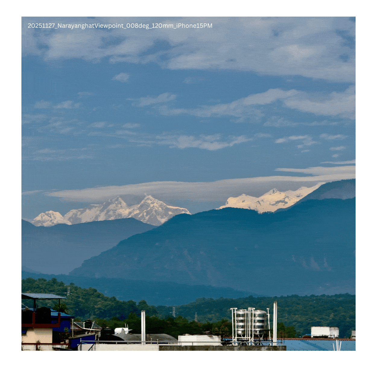
That mountain on the Narayanghat horizon is Manaslu, the world's 8th highest peak
There is a mountain you can see from Narayanghat, and all over Chitwan, if you look almost due north on a clear day.
When you are in Nepal, you are never too far away from the Himalayas. Growing up in Chitwan, mountains were a common sight. After the end of monsoon, between September to December, almost due north from Narayanghat, a few triangular summits hover just above the blue-green line of the Mahabharat hills. They glow orange in the first light and show up as lush white throughout the day. I grew up in Chitwan and saw the summits hundreds of times, riding along the local road, crossing the Narayani bridge, eating at the thelas on Narayani Riverside. I always assumed they were indistinct mountains. One of those far-off white things.
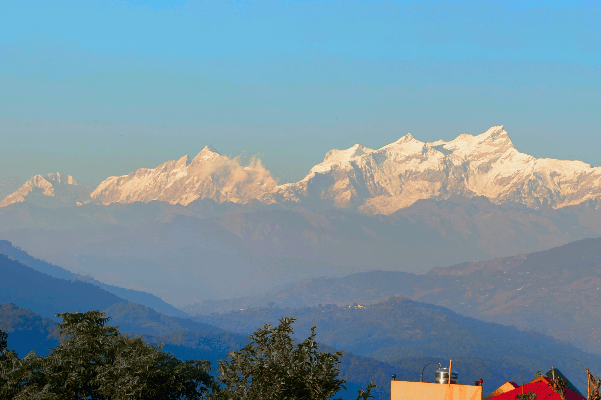
In October 2025 I photographed the summits properly for the first time and looked at the image closely. There were 3–4 peaks that were distinct and towered above all other geographical features. The profile was too clean. Too tall relative to everything around it. That is not a foothill. I started calculating.
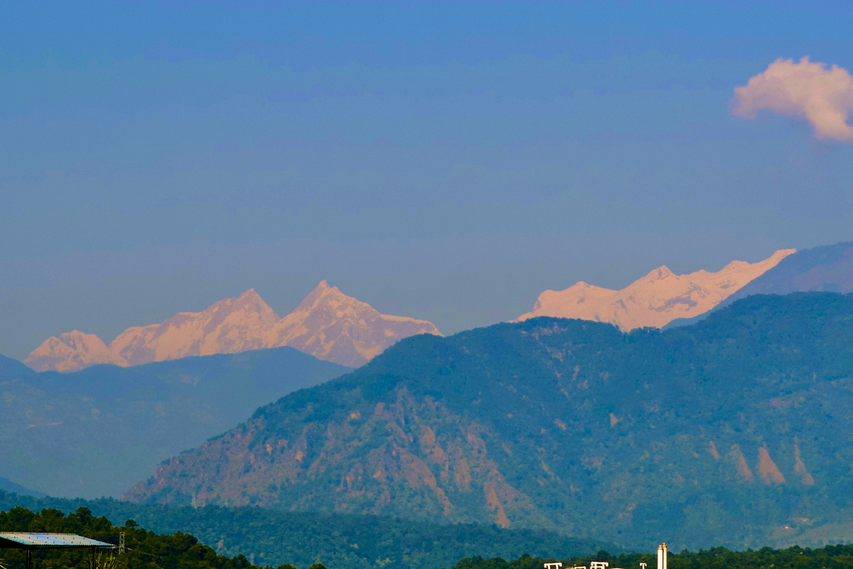
Nov 26, 2025 - Close up view of the most prominent summits seen from Narayanghat, looking due North.
Where I was shooting from
Nepal talks constantly about its proximity to the Himalayas, Kathmandu has Langtang, Pokhara has Annapurna, Namche has Everest in its backyard. Narayanghat has never been part of that conversation. But on any clear day between October and February, looking due north, from anywhere in Narayanghat where you have a clear line of sight to the horizon, you can see the eighth highest mountain in the world.
Here are all the spots from which I photographed it — eight distinct locations spread across Chitwan and Gorkha. The coloured wedges are the representative of fields of view from each position, all pointing roughly north.
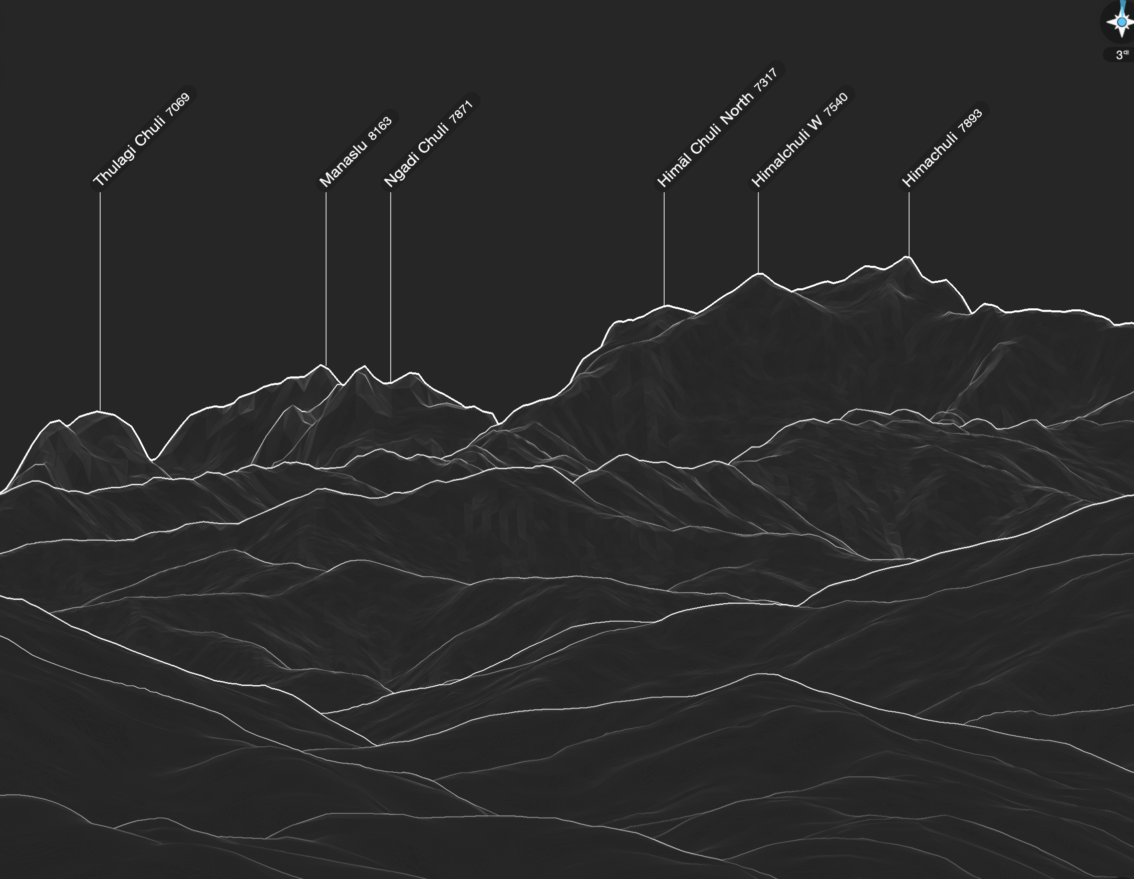
A quick bearing search from any of those GPS coordinates, pointed north, returns the same answer: Thulagi Chuli (7,059 m), Manaslu (8,163 m), Ngadi Chuli (7,871 m), and Himalchuli (7,893 m) — four peaks over seven kilometres tall, visible from the jungle city best known for wildlife safaris. The dominant triangular one on the left is Manaslu, the world’s eighth highest mountain.
Out of the eight locations I used for taking the photos, I had a clear line of sight to Manaslu from six of them. From higher latitudes (and altitude, co-incidentally) in Chopprak, Gorkha and Siran Danda, Gorkha, the view of Manaslu was obstructed by other peaks in the region like Himalchuli and Nagdi Chuli.
December 13, 2025 - From Chhoprak, Gorkha, The parallex effect causes Manaslu to hide behind Nagdi Chuli (left most peak in the picture)
Does the Earth’s curvature block it?
The first thing I wanted to verify was whether a 96 km line of sight to an 8,163 m peak was even geometrically possible from 194 m altitude in Narayanghat.
Step 1 — How far is the horizon?
Stand at height h above a sphere of radius R. Your line of sight just grazes the surface at the horizon point, forming a right angle there. That gives a right triangle: hypotenuse R + h, one leg R, the other leg d (horizon distance).
This comes directly from Euclidean geometry and the Pythagorean theorem.
(R + h)² = R² + d² → d² = 2Rh + h²
Since h (194 m) is tiny compared to R (6,371 km), h² is negligible:
d ≈ √(2Rh) = √(2 × 6,371 km × 0.194 km) ≈ 49.7 km
This is the standard distance to horizon result.
Step 2 — How much does the earth’s curvature and atmosphere hide?
For anything beyond the horizon, the Earth curves away underneath your line of sight.
Near the top of a sphere, the surface drops below a tangent line by an amount that grows with the square of distance. This comes from the geometry of a circle.
From the circle equation (x² + y² = R²), the vertical drop near the tangent point approximates to:
drop ≈ d² / (2R)
Light doesn’t travel perfectly straight through the atmosphere. Because air density decreases with altitude, light bends slightly downward — a phenomenon explained by Atmospheric refraction.
Rather than re-deriving everything, we adjust the Earth’s radius:
R_eff = R / (1 − k)
Where:
- k ≈ 0.13 (standard refraction coefficient)
This makes the Earth appear less curved, increasing the horizon distance (see Refraction).
So the horizon extends from:
- 49.7 km → 53.3 km
Applying this to Manaslu
Manaslu is 95.9 km away — about 42.6 km past the refracted horizon.
The curvature drop at that excess distance:
(42.6 km)² ÷ (2 × 7,323 km) ≈ 124 metres hidden
Of Manaslu’s 8,163 m height:
- 124 m (~1.5%) is hidden
- 8,039 m remains visible
Manaslu is ~8 km tall. It easily “sticks out” above the curvature.
Step 4 — Angular size
Angular size comes from basic geometry and trigonometry (see Angular diameter).
For small angles:
θ ≈ height / distance
So:
θ ≈ 8,039 m / 95,900 m ≈ 0.0838 rad ≈ 2.31° ≈ 138 arcminutes
For comparison:
- The Moon subtends ~0.52° (~31 arcminutes)
So Manaslu, from Narayanghat (and Chitwan in general) appears ~4.4× taller than the Moon is wide
The golden shot
The photo that confirmed everything for me was taken on November 14, 2025 at the Narayanghat Viewpoint.
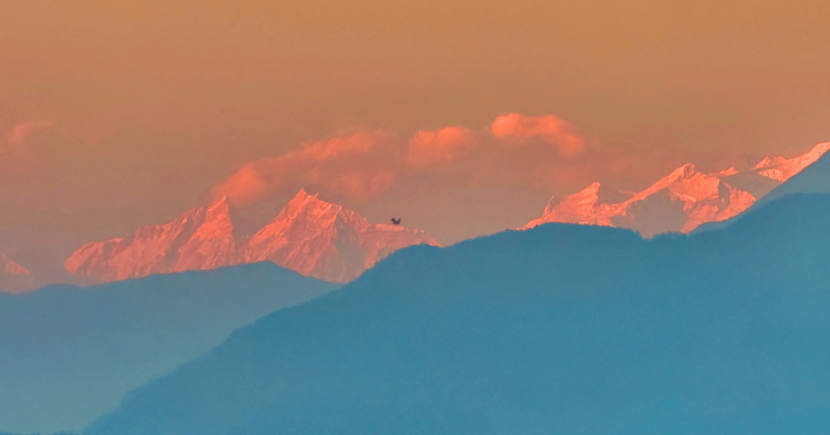
Nov 14, 2025 - The high-altitude snowfield catching direct sunlight while the terrain below is still in Earth's shadow..
Hills don't do this. Ridgelines don't do this. An 8,000 m summit does.The triangular shape mattered too. That silhouette, clean, symmetrical, unmistakable, is the south face of Manaslu. The face that points toward Chitwan.
An animated GIF showingsome photos of Manaslu from Narayanghat, and a peakfinder screenshot outlining the peaks visible, with peaks lined up
The photogrammetric table
For the photos in this project I ran the same calculation: extract GPS from EXIF, compute geodesic bearing to Manaslu’s summit (28.5495°N, 84.5597°E), correct field of view for any iOS crop using ExifImageWidth/ExifImageHeight (which preserve the native sensor dimensions even after export), then predict the pixel position of Manaslu in the stored image.
The result across 8 independent photos, six GPS locations,: predicted pixel position matched the visually identified position to within 3°–5°. As a refernce, the table below shows the bearing and distance to Manaslu and other peaks in the area from Narayanghat, Chitwan.
| Peak | Bearing | Distance |
|---|---|---|
| Manaslu | 8.07° | 95.9 km |
| Ngadi Chuli | 12.04° | 94.9 km |
| Himalchuli | 14.39° | 84.9 km |
Driving toward it
In December I drove north to see what the view looked like from closer in.
At Syauli Bazaar in Gorkha district (416 m, 66 km from the summit), the elevation angle climbs from 4.75° to 6.69° and Manaslu visibly fills more sky. I pulled up PeakFinder on GPS and it confirmed the arrangement immediately:
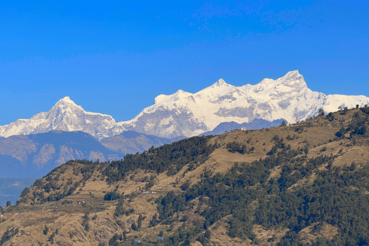
Dec 12, 2025 - Manaslu and other peaks in the region seen from Syauli Bazaar, Gorkha.
PeakFinder at Syauli Bazaar. Thulagi Chuli, Manaslu, Ngadi Chuli, Himalchuli left to right, the same ordering as every Chitwan photo.
That left-to-right sequence is identical to what’s visible from the Narayanghat bypass road. The bearing to Manaslu shifts slightly as you move north, but the sequence doesn’t change.
What changes as you drive further north is the relative geometry of the peaks. From Chhoprak at 1,278 m, Manaslu’s summit starts to tuck behind Ngadi Chuli as the angular separation between them narrows with proximity. From Siran Danda at 1,977 m, Manaslu has swung north-west and you’re looking at the south-east face of Himalchuli from 29 km.
Where to go to view Manaslu
Narayanghat gets great views of Manaslu as long as you can find open skies facing north.
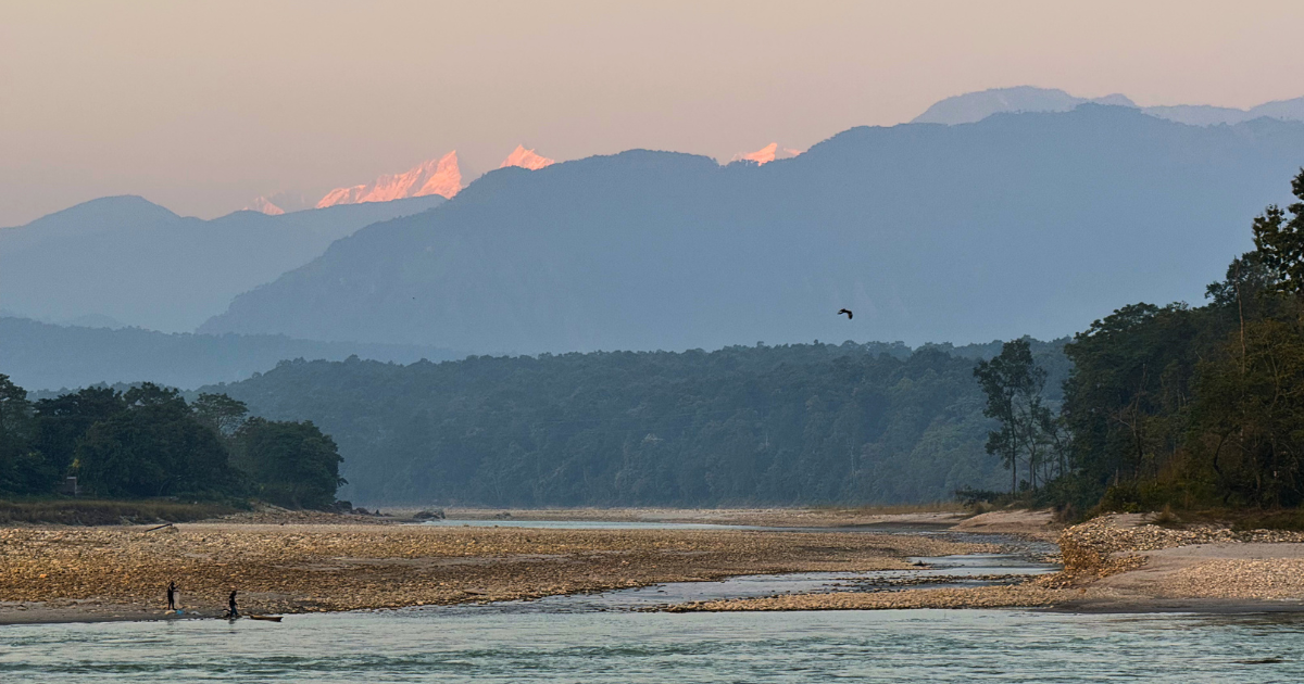
Narayani Riverside, just north of the Narayani bridge, gives an unobstructed view across the river flats with Manaslu further left in the frame.
Tikauli in Ratnanagar, across the Rapti to the south, shifts the bearing to 4°. Worth the comparison if you’re making both shots in the same morning.
Syauli Bazaar in Gorkha is the best option if you feel like driving. At 416 m and 66 km from the summit, Manaslu is taller in the sky and the PeakFinder labelling is unambiguous.
September to December season is the best, on a clear day, just look north where you are clear line of sight to the horizon. The mountain does the rest.